|
ABOUT THIS WEBSITE
Recently I have been adding more maps to the site. I just finished going through Redstone QM, making sure that all meetings regardless of branch have a short historic narrative and a map. I am working though all meetings, proceeding west (Salem and Springfield QMs are next) and then south (Short Creek, Stillwater, and other QMs). Once I have completed this project, I plan to add maps for the PMs, MMs, and QMs, which will show all meeting houses within their verge on the same map.
The pins on the maps are as precise as I can make them, and in the description I have stated whether the pins are an estimated location. For some short-lived meetings, I have not come across any information about the location of the meeting, and for others all the information that I have is the municipality. Where possible, the pins indicate the precise location of the meeting house. This information will help anyone who wants to visit the property to be able to locate it.
I am also adding information about the individual meeting houses. When I have them, I am adding deed references to the description in case anyone wishes to look up the deed. I have photocopies of most of the deeds that I cite.
OHIO YM HISTORIC ATLAS
 The Historic Atlas of Ohio Yearly Meeting was published by Ohio Yearly Meeting in
2012 as a part of its bicentennial commemoration. The book is an illustrative
companion to the existing histories of Ohio YM, although it contains some new
research. All copies sold within a year.
Ohio Yearly Meeting of 2013 authorized the publication of additional copies of the Historic
Atlas. The 2014 version, which remains available for purchase, contains revisions to the original text, additional information, and an additional two-page spread to discuss the YM's bicentennial. The price remains $15.
Ohio YM Quick Links
MEMBERS RECENTLY EDITED
MEETINGS RECENTLY EDITED
|
New Information about Redstone Meeting
Seth Hinshaw, 6/6/2021
In 2009 I drafted a graphic showing the land history of the Redstone Meeting property in Brownsville, Pennsylvania. Since that time I have found additional information so I am making a new post about Redstone.
Let's start by discussing the location of the meeting house. Historians unanimously state that the meeting house stood on Prospect Street, which was the historic northwest boundary of the property. A former schoolhouse currently used as a retirement home stands on the former Redstone property, just off Prospect Street, and it is probably due to this prominent building, overlooking the downtown, that historians assumed that the former schoolhouse stands on the former meeting house site.
However, take a look at this clip from the William J. Barker, Map of Fayette County, Pennsylvania, From actual Surveys, published in 1858. It shows the meeting house along Angle Street near the southwestern boundary of the property, with the burial ground behind it and the schoolhouse further west:
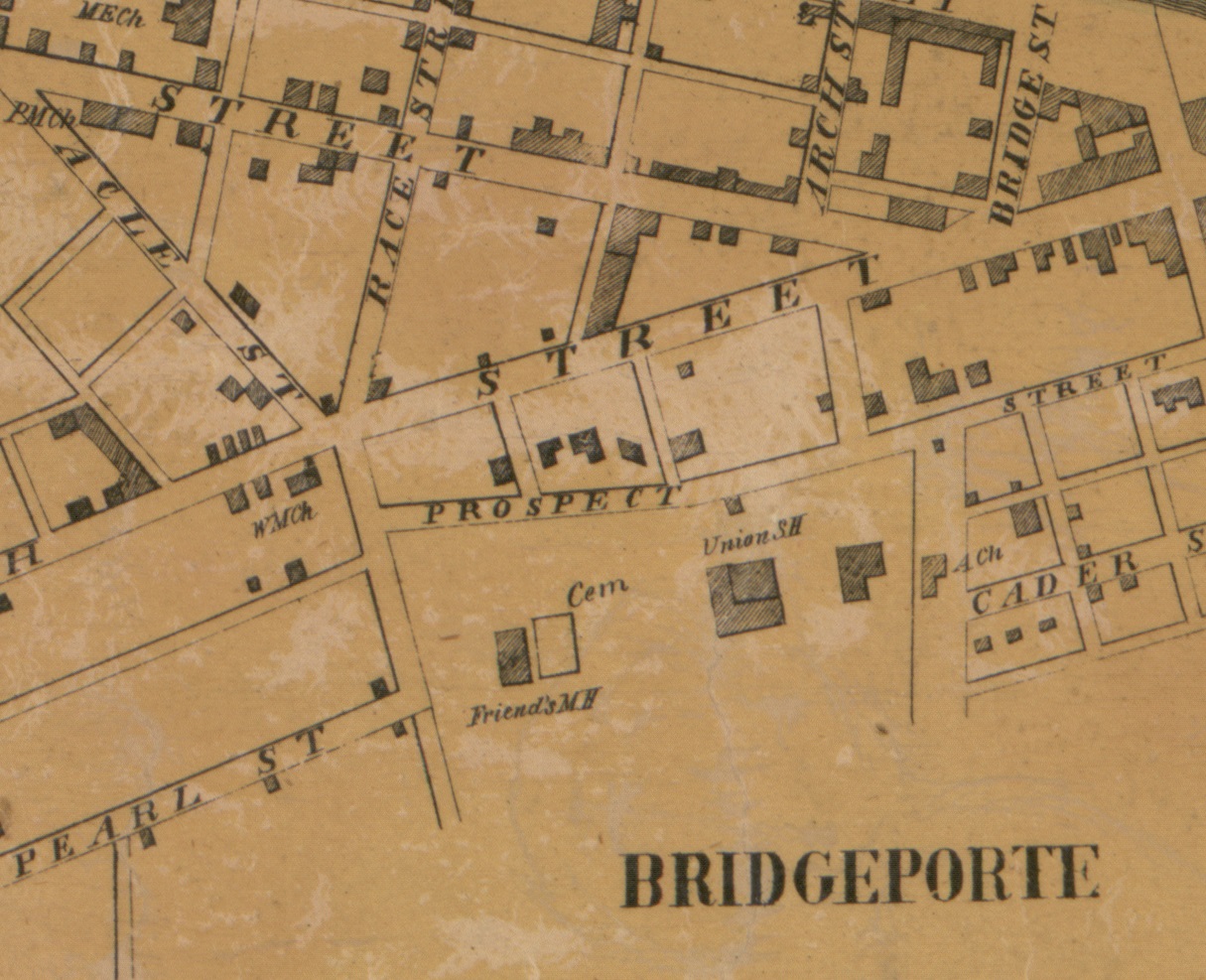
Not only does the map show the Redstone Meeting House along Angle Street, but it also shows a school on the site of the current schoolhouse/retirement home. This information is consistent with other records.
In the mid-1850s, the Brownsville school directors approached Redstone MM (Orthodox) to ask about purchasing vacant land at the northeastern end of the meeting property for the construction of a new school house. The school board agreed to make five annual payments for the property. In the meantime, the Wilburite-Gurneyite division occurred. The school board made its payment in 1855 to Aaron Branson of the Wilburite side, unaware of the division. The Gurneyites initiated a lawsuit to eject the school board for failure to continue the payments. The various parties reached an agreement, and a deed was finalized in 1859 selling the property (Fayette County Deed Book 12-77).
At the time of the 1854 division, the two factions shared the meeting house. The Wilburites worshipped in the room called the west room (actually the northwest room), the former meeting place of the Hicksites, and the Gurneyites worshipped in the east room (actually the southeast room). The Wilburite meeting was laid down in late 1865, and the Gurneyite meeting was laid down the following year.
When Redstone Meeting (Gurneyite) was laid down, the Gurneyites decided to dispose of the remaining property. They created a large building lot along Prospect Street that they sold to Oliver C. Cromlow in 1866 (Deed Book 19-606). The meeting house stood on a smaller lot off Angle Street; the Gurney trustees demolished the meeting house and sold the lot to E.N. Coon (Deed Book 19-517). The burial ground remained on a flag lot accessed by a lane along the southeastern side of the Coon lot. The Wilburites discovered what had happened, and in 1868 they filed deeds conveying their interest in the properties to Cromlow and Coon (Deed Book 20-240 and 20-329).
Below is a clip of the tax parcel map overlaid onto an aerial that is on the Fayette County (Pennsylvania) GIS site, showing the area:
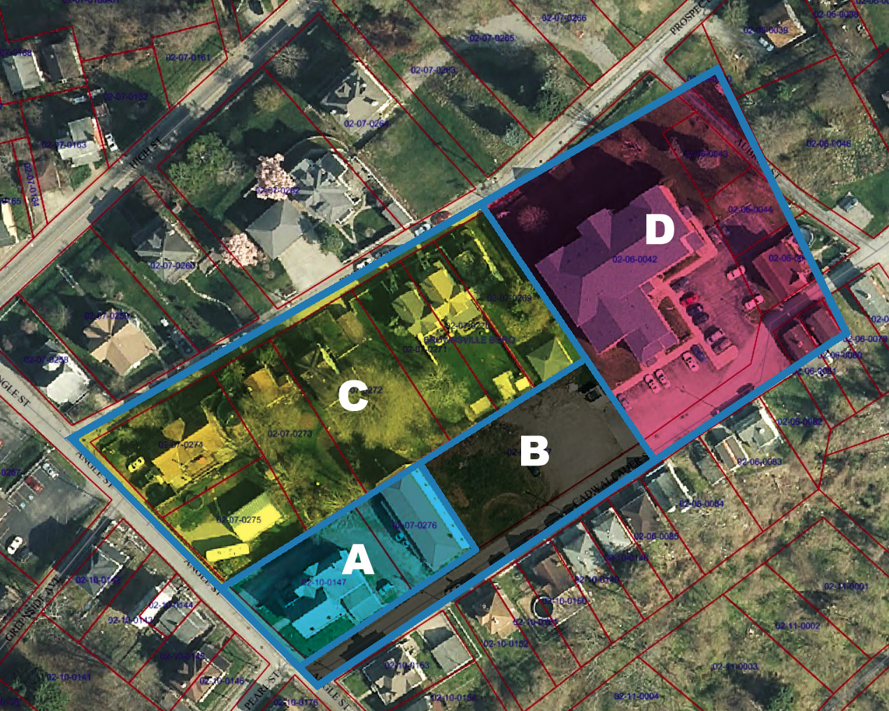
The map shows the overall property that Rees Cadwalader conveyed to Redstone Monthly Meeting in 1799. Parcel A is the meeting house lot, which was sold to E.N. Coon in 1866/1868. Parcel B is the burial ground lot; it was created as a flag lot. The lane along the southeastern boundary, originally intended to access the burial ground, came into use to access the school, and in the early twentieth century the lane became part of Cadwalader Street. Parcel C is the larger building lot sold to Oliver C. Cromlow in 1866/1868. Parcel D is the School Lot of 1859.
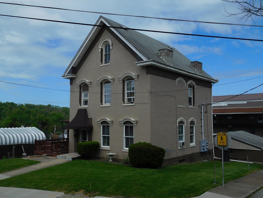
A house was built near the site of the meeting house; the meeting house would have stood just behind the house. This existing house has the street address of 135 Angle Street. Here is a photo of that house taken in 2020:
The borough of Brownsville entered into negotiations with the Gurneyites in the mid-twentieth century, relocating all remains from the burial ground to the Brownsville cemetery at the end of Angle Street, then purchasing the remaining property in 1955. These actions were also completed without notifying the Wilburites, who had a 50% interest in the burial ground.
|
